News

How Water Moves the Land and How You Can Control It

By Nick Kremp, PCCD Head Resource Conservationist
Have you ever been struck by the beauty of a sweeping valley or a dramatic hillside and wondered, “How did this come to be?” Often, a large part of the answer is simply water and time. The flow of water plays a huge role in shaping the landscape and vice versa. Watercourses like the Delaware River are particularly great places to see this process in action. Here we can see where erosion (the dislodging and removal of sediment and rock, mainly by water) causes steep, rocky slopes and cuts through mountains of material over time. We can also see sedimentation (the deposition of eroded material in a new location) creating sand bars and floodplains along the banks composed of sandy material washed down from further up the watershed. Sudden, large changes to geology, as in construction and site development, often lead to dramatic changes in the erosion potential of a site. Because of this interplay, it is important to consider factors of a site such as soil types, slope, and the presence of water when planning to minimize erosion and sedimentation. By implementing accepted erosion and sediment control best management practices (E&S BMPs), we can avoid having our projects undercut or buried by these geologic forces.
There are many types of soil with varying characteristics such as particle sizes, structure, and permeability. These characteristics all affect the way that water passes through the soil. As an example, sandy soils tend to have larger particle sizes with a lot of space between the particles for water to flow through and so tend to be well draining. Soils with a higher clay content have smaller particle sizes with less overall space between the particles and tend to drain water more slowly. Many E&S BMPs such as silt fences and filter socks work on the principle of slowing water down and allowing sediment particles suspended in the water to settle out behind the BMP. Soils with low infiltration and high surface runoff may consider using E&S sediment basins as opposed to filter socks. Another E&S BMP which works to filter runoff is a vegetation filter strip. A vegetation filter strip is essentially an area with established vegetation, such as grass. Soils with a lot of organic material and roots from established vegetation have a stable structure which is harder to erode than bare soil with little organic material, making filter strips effective E&S BMPs, assuming they are wide enough to treat a particular site’s disturbed area.
In the Pocono region, we are no strangers to sloped landscapes. Water runs downhill and the steeper the slope, the faster it runs. The faster water runs, the more energy it carries to erode the underlying soil. Certain E&S BMPs are available in a range of sizes which are suitable for use on slopes depending on the steepness and length of the disturbed area above the BMP. Structural BMPs such as waterbars and broad-based dips may be needed on logging roads along a slope to prevent washing out of the road and to divert water to a drainage channel or sediment removal device. Slopes naturally encourage water to form into channels which can lead to concentrated flows and subsequent failure along an E&S BMP. When established E&S BMPs are damaged in this way, temporary BMPs such as rock filters, can be utilized to continue filtering water flowing through the compromised barrier.
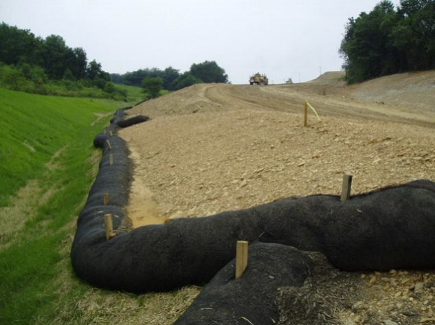
Compost filter sock, a possible ABACT BMP for work in special protection watersheds
Pike County is lucky to have many high quality and exceptional value watersheds. These descriptions might sound like hyperbole, but they are official designations of our streams and wetlands based on biological and physical qualities which set them apart as especially clean and productive ecosystems. They also require stricter protection and limit the number of acceptable E&S BMPs for projects to a subset of BMPs or combinations of BMPs known as ABACT (anti-degradation best available combination of technologies). Since even relatively small sedimentation events can change the quality of a stream dramatically by clouding the water and filling a rocky stream bed with mud, ABACT and BMPs in general are critical to maintaining their ecological and drinking water value. Pike County is crisscrossed by many of these exceptional value and high-quality waters, so it is critical that one knows the receiving waters (the watercourse which your site ultimately flows to) and its official designation. If you are unsure which watershed your project is in, you can always reach out to our technical staff at your local conservation district for help.
Although erosion is a geological process happening all the time all over the Earth, humans can have a dramatic impact on the rate of erosion through our land development and construction. As their name not so subtly suggests, erosion and sediment best management practices, when properly selected and utilized, are the best way for us to temper the impact of earth disturbance activities. So, before you start work on a site, consider the impact erosion has had on our region in the past and how you can best manage erosion and sedimentation today.